The story so far
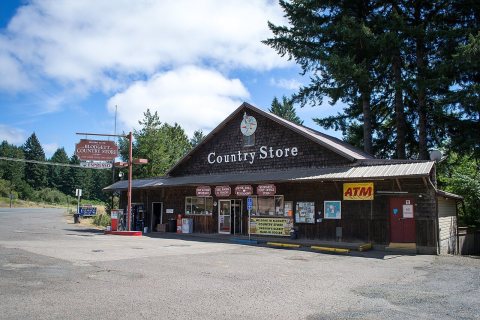
from Wikipedia & the U.S. CensusBlodgett is a census-designated place (CDP) and unincorporated community in Benton County, Oregon, United States, where Oregon Route 180 meets U.S. Route 20 in the Central Oregon Coast Range 15 miles (24 km) west of Corvallis. It is near the confluence of the Tumtum and Marys rivers. As of the 2020 census, the community had a population of 42. Blodgett was named for pioneer settler William Blodgett. The post office was established in April 1888 with the name "Emrick", for a local family, and was changed to Blodgett shortly thereafter. Its ZIP code is 97326. Blodgett is part of the Philomath School District. The 38-student Blodgett Elementary School serves kindergarten through fourth grade; …
Between the 2010 and 2020 censuses its population fell from 58 to 42 (-28%).
Wikipedia doesn’t have a history of Blodgett yet — the old photos, dates and memories neighbors add here are how it gets written.
Intro from Wikipedia, licensed CC BY-SA 4.0. Population and housing: U.S. Census Bureau.
Start Blodgett’s collection
The first neighbors to add old photos shape how Blodgett’s history is told.
0 of 10 decades since 1900 have photos 📦Share a family photoSign in to add one+10Famous people close to Blodgett
See all 23 →

Blodgett, decade by decade
2000
Nothing in Blodgett is on the National Register yet
That’s true of most small towns. It doesn’t mean Blodgett has no history, only that no one has written up a nomination. The closest listed place is Harris Bridge in Blodgett, 3.2 miles away.
Blodgett and the nearest listed places


How a place gets listed
Then & now
When neighbors add old photos, retakes from the same spot appear here side by side.
Stories next door
nearby towns’ historyFrom Wikimedia Commons (1). Images are copied here with their credits and licenses, shown on each photo’s page. Refreshed monthly.