Save town Compare Needs More Love
Town guide

Lansing

A town of 126 people in North Carolina
Be the first to joinEarn karma for joining →
1

Now in Lansing

What’s happening this week

All posts →
This week+ What’s happening in Lansing?
From your neighbors

What’s happening

A preview of what neighbors share. Be the first to post in Lansing.

Weather

Forecast →
Coming up

Upcoming events

Nothing on the calendar yet

Put the next local happening — a market, a meeting, a concert — on the map.

Add an event →
Around town

Local news

All news →

Headlines via Google News · Articles belong to their publishers.

2

Around town

The places and views that make it Lansing

Explore places →

Outdoors in Lansing

Parks & trails →
Conserved land27%66 of 241 acres
Trails0.3 mi0.8 mi per sq mi
Parks & preserves1named on the map

Know a trail or park that’s missing? Anyone can add it to OpenStreetMap, and it shows up here on the next refresh.

Trails & parks © OpenStreetMap contributors · Conserved land: USGS PAD-US

3

Know Lansing

The town at a glance, and the guide to how things work

Open the full guide →

About Lansing

Town in North Carolina, United States
1928Established
126Population
0.3 sq miArea
2,664 ftElevation

Lansing is a resort town in Ashe County, North Carolina, United States. The population was 126 at the 2020 census. Lansing is a popular destination among retirees and tourists from Florida, as well as those from the lower elevations of the Carolinas and Georgia.

Official town website ↗

From Wikipedia, licensed CC BY-SA 4.0 · facts via Wikidata (CC0)

Town numbers

ZIP code28643
Area code336
Living in Lansing

Housing in Lansing

$286K▲ 3.4% in a year Typical home value · Zillow

The typical Lansing home is worth about $286,000, up 3.4% in a year, 15% below the North Carolina typical home.

Zillow Home Value Index · Redfin Data CenterHousing market →

Work & commute in Lansing

Full picture →

Most working residents leave Lansing for work: only 0% work in town. The top destinations are Jefferson (19%), West Jefferson (13%) and Boone (7%). Half commute less than 8 miles.

Jefferson
19%
West Jefferson
13%
Boone
7%
Charlotte
5%
Census LEHD 2023 · ACSWork & commute in Lansing →

Health in Lansing

Compared with North Carolina

8worse than NC

of 32 measures CDC estimates. The other 24 are too close to call.

BetterToo close to callWorse

What stands out

Care nearby

Ashe Memorial HospitalJefferson · 6 mi · ER · rural critical access
Appalachian District Health Department Dental CenterJefferson · 5.8 mi · sliding-scale fees
Primary careShortage · county-wide
DentalShortage · county-wide
Mental healthShortage · county-wide
CDC PLACES 2025 · modeled estimates for adults · CDC's estimate for Lansing · CMS · HRSAHealth in Lansing →

Natural hazards in Lansing

85
Very high

Expected storm and flood damage is higher than in 85% of U.S. communities.

🌊 Inland flooding🥶 Cold waves
FEMA National Risk Index December 2025 · OpenFEMANatural hazards in Lansing →

Climate in Lansing

Full climate →

Lansing has chilly winters and pleasant summers. A typical July afternoon reaches 81°, a January night drops to 23°, and about 14 inches of snow falls in a normal winter.

45° / 24°Winter
63° / 37°Spring
80° / 56°Summer
65° / 40°Fall
NOAA U.S. Climate Normals, 1991–2020Climate in Lansing →

Libraries near Lansing

See all →
Nearest: Ashe County LibraryWest Jefferson · 6.9 miles · 53 hrs a week

Famous people from Lansing

See all 1 →

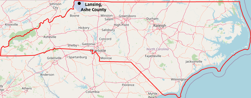
Where Lansing is

Explore map →
Locator map of Lansing
Wikimedia Commons · Map: DescriptionLansing (Caroline du Nord).png This map was created from OpenStreetMap project data, collected by the community. This map may be incomplete, and may contain errors. Don't rely solely on it for navigation. Date (see file history) Source OpenStreetMap.org Creator OpenStreetMap contributors Permission(Reusing this file) OpenStreetMap data is available under the Open Database License (details). Map tiles are licensed under the Creative Commons Attribution-ShareAlike 2.0 license (CC-BY-SA 2.0). This work contains information from OpenStreetMap, which is made available under the Open Database License (ODbL). The ODbL does not require any particular license for maps produced from ODbL data. Prior to 1 August 2020, map tiles produced by the OpenStreetMap Foundation were licensed under the CC-BY-SA-2.0 license. Maps produced by other people may be subject to other licences.Open Database LicenseODbLhttp://opendatacommons.org/licenses/odbl/1.0/true This file is licensed under the Creative Commons Attribution-Share Alike 2.0 Generic license. You are free: to share – to copy, distribute and transmit the work to remix – to adapt the work Under the following conditions: attribution – You must give appropriate credit, provide a link to the license, and indicate if changes were made. You may do so in any reasonable manner, but not in any way that suggests the licensor endorses you or your use. share alike – If you remix, transform, or build upon the material, you must distribute your contributions under the same or compatible license as the original.https://creativecommons.org/licenses/by-sa/2.0CC BY-SA 2.0 Creative Commons Attribution-Share Alike 2.0 truetrue Georeferencing Georeference the map in Wikimaps Warper If inappropriate please set warp_status = skip to hide. · CC BY-SA 4.0

Location map

How things work in Lansing

All explainers →
We left the porch light on

Where to, neighbor?

You’re in Lansing, NCView boundary

Nearby

All towns & citiesExplore the map
Loading boundary…

Lansing is your selected town. The feed includes posts assigned to this town, not a distance radius or ZIP code.

Neighborhoods narrow the feed further, while townwide announcements, events, and issues remain visible.

Boundary source: https://tigerweb.geo.census.gov/arcgis/rest/services/TIGERweb/Places_CouSub_ConCity_SubMCD/MapServer/18 · 2025-01-01